Welcome to Partnership Initiatives of United Nations Department of Operational Support Overview About Us Governance Structure Members CI Contact Us What We Do DWG 1: Hybrid GIS Platform DWG 2: Capacity Building DWG 5: GEOAI & Analytics DWG 6: OpenDroneMap & 3D DWG 7: Smart Maps Best Practices Resources SW Downloads Source Codes Documents News and Media News and Media Meeting Schedule News Videos Photos Call for Participation Home Overview Overview About Us Governance Structure Members CI Contact Us What We Do What We Do DWG 1: Hybrid GIS Platform DWG 2: Capacity Building DWG 5: GEOAI & Analytics DWG 6: OpenDroneMap & 3D DWG 7: Smart Maps Best Practices Resources Resources SW Downloads Source Codes Documents News and Media News and Media News and Media Meeting Schedule News Videos Photos Call for Participation
Welcome to Partnership Initiatives of United Nations Department of Operational Support Overview About Us Governance Structure Members CI Contact Us What We Do DWG 1: Hybrid GIS Platform DWG 2: Capacity Building DWG 5: GEOAI & Analytics DWG 6: OpenDroneMap & 3D DWG 7: Smart Maps Best Practices Resources SW Downloads Source Codes Documents News and Media News and Media Meeting Schedule News Videos Photos Call for Participation Home Overview Overview About Us Governance Structure Members CI Contact Us What We Do What We Do DWG 1: Hybrid GIS Platform DWG 2: Capacity Building DWG 5: GEOAI & Analytics DWG 6: OpenDroneMap & 3D DWG 7: Smart Maps Best Practices Resources Resources SW Downloads Source Codes Documents News and Media News and Media News and Media Meeting Schedule News Videos Photos Call for Participation
Overview About Us Governance Structure Members CI Contact Us What We Do DWG 1: Hybrid GIS Platform DWG 2: Capacity Building DWG 5: GEOAI & Analytics DWG 6: OpenDroneMap & 3D DWG 7: Smart Maps Best Practices Resources SW Downloads Source Codes Documents News and Media News and Media Meeting Schedule News Videos Photos Call for Participation
Overview About Us Governance Structure Members CI Contact Us What We Do DWG 1: Hybrid GIS Platform DWG 2: Capacity Building DWG 5: GEOAI & Analytics DWG 6: OpenDroneMap & 3D DWG 7: Smart Maps Best Practices Resources SW Downloads Source Codes Documents News and Media News and Media Meeting Schedule News Videos Photos Call for Participation
Overview About Us Governance Structure Members CI Contact Us What We Do DWG 1: Hybrid GIS Platform DWG 2: Capacity Building DWG 5: GEOAI & Analytics DWG 6: OpenDroneMap & 3D DWG 7: Smart Maps Best Practices Resources SW Downloads Source Codes Documents News and Media News and Media Meeting Schedule News Videos Photos Call for Participation
Home Overview Overview About Us Governance Structure Members CI Contact Us What We Do What We Do DWG 1: Hybrid GIS Platform DWG 2: Capacity Building DWG 5: GEOAI & Analytics DWG 6: OpenDroneMap & 3D DWG 7: Smart Maps Best Practices Resources Resources SW Downloads Source Codes Documents News and Media News and Media News and Media Meeting Schedule News Videos Photos Call for Participation
Home Overview Overview About Us Governance Structure Members CI Contact Us What We Do What We Do DWG 1: Hybrid GIS Platform DWG 2: Capacity Building DWG 5: GEOAI & Analytics DWG 6: OpenDroneMap & 3D DWG 7: Smart Maps Best Practices Resources Resources SW Downloads Source Codes Documents News and Media News and Media News and Media Meeting Schedule News Videos Photos Call for Participation
Home Overview Overview About Us Governance Structure Members CI Contact Us What We Do What We Do DWG 1: Hybrid GIS Platform DWG 2: Capacity Building DWG 5: GEOAI & Analytics DWG 6: OpenDroneMap & 3D DWG 7: Smart Maps Best Practices Resources Resources SW Downloads Source Codes Documents News and Media News and Media News and Media Meeting Schedule News Videos Photos Call for Participation
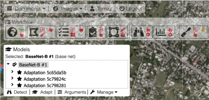
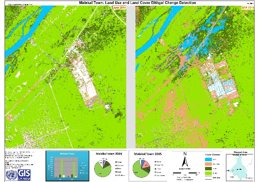
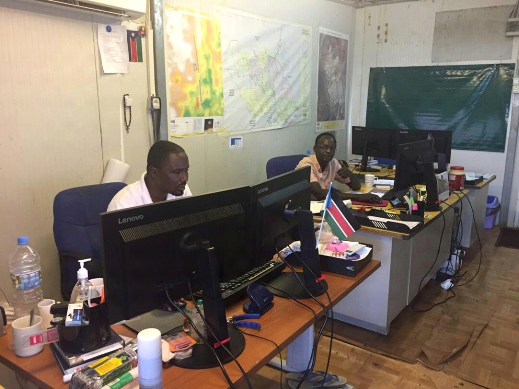
[Best Practice] Mapping Refugee Settlements by using PulseSatellite [Best Practice] Implementing the UN Open GIS Initiative in United Nations Mission in South Sudan [Best Practice] QGIS+ Malakal GIS Team in UNMISS